Rand McNally
Rand Mcnally Kids' Illustrated World Wall Map - Folded
Rand Mcnally Kids' Illustrated World Wall Map - Folded
ISBN-13: 9780528026713
Precio habitual
$12.48
Precio habitual
Precio de oferta
$12.48
Precio unitario
/
por
Los gastos de envío se calculan en la pantalla de pago.
No se pudo cargar la disponibilidad de retiro
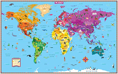
Rand McNally's Kids' Illustrated Map of the World is designed to spark curiosity in young minds. Vibrant colors and playful graphics encourage children to have fun while learning about geography, botany, zoology, history, and architecture all across the globe. As decorative as it is educational, this contemporary color palette with an elegant white border makes this map suitable for framing and is the perfect addition to any bedroom or playroom. - Color-coded continents have delightful illustrations of native plants, animals, landmarks, cultural icons, and more. - Labeled capitals, major cities, and bodies of water provide additional points of reference. - Printed on heavy paper for extra durability. - Perfect for children's bedrooms, playrooms, or classrooms. Product Details: - Dimensions: 50 x 32. - Folded dimensions: 8 x 11. - Package: Shrink-wrap.
- • Author: Rand McNally
- • Publisher: Rand McNally
- • Publication Date: May 19, 2022
- • Number of Pages: Not Available pages
- • Language: English
- • Binding: Map
- • ISBN-10: 0528026712
- • ISBN-13: 9780528026713
Share